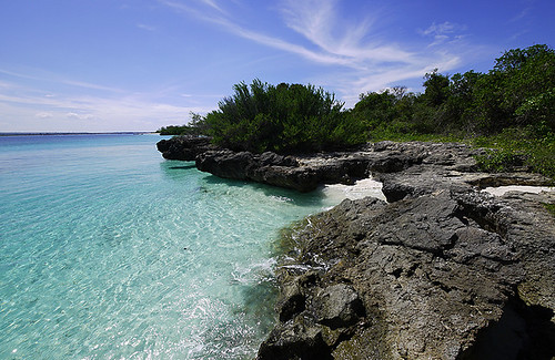
Mbudya Island (simply Mbudya) is an uninhabited island in Tanzania, north of the Country's capital city, Dar es Salaam and is one of the four island of the Dar es Salaam Marine Reserve (DMRS).
The Island lies close to the beach resort and fishing Community of Kunduchi and is reachable by means of a 20 minutes motorboat ride crossing from the mainland. It is therefore a popular daytrip for both tourists and Tanzanian residents alike, serving as a location for a variety of leisure activities, including snorkeling, sunbathing and hiking.
The Island offers fabulous snorkeling and diving opportunities and is a fourable day outing for visitors to the section of Tanzania coast. Mbudya Island is situated about 3km offshore, within easy reach of the hotels on the north coast of Dar es Salaam.
There are hereby sand beaches on the western and eastern sides. On the western side, it is possible to have barbecued fish with chips and drinks. There is plenty of shade under the casuarina trees.
There is a washroom located near the resting beach. On the beach there are bandas where you can rest while enjoying chips with fish and soft drinks.
Mbudya is a home of Crabs.
Snorkeling, Diving, hiking and sunbathing.
The Island is covered with dense stands of Palms and Baobabs. The rare Coconut crabs are found on the Island. To get to the Island, one of many local motorized dhow and ngalawa can be hired. The hotels like White Sands, Silver Sands, Kunduchi beach, Beach Comber and Bahari beach are able to provide more modern transport to the Island.
This unhabited Island is about a 30 minutes ferry or boat ride from Dar es Salaam, and is part of the Dar es Salaam Marine Reserve. Snorkeling, Hiking and Exploring are delightful activities that visits can engage in Bongoyo Island.
Bongoyo Island Geography.
Bongoyo Island may be uninhabited, but its not just a dry rock. Dozens of plants and trees native to East Africa make the Island their home among the sand dunes. Still the sun is strong on Bongoyo Island, so be sure to bring sunscreen, a hat and sunglasses. Soft white sand beaches, make up part of Bongoyo Island coast, which are wonderful for walking or sunbathing. Underneath the Ocean waters, explorers will find coral reefs, home to dazzling sea life such as sea urchin,shrimps and butterfly fish. Be sure to bring snorkeling gear, to better observe these fascinating creatures.
Activities on Bongoyo Island.
Bongoyo Island is a popular destination for those looking to get away from civilization for a while.There are plenty of Snorkeling opportunities in places like Shark's Lagoon cave (so named from the young Shark's that swim along the shores hunting octopi). Hiking around Bongoyo is also popular, yet many visitors like to simply sit on the beach with a good book or relax with a picnic.
For a great day
trip, one may head out to Bongoyo Island, which is a small, uninhabited
island just off the coast. The boat to Bongoyo leaves from Slipway, along
Msasani Peninsula, north of Dar-Es-Salaam. A taxi from the city center may
cost Tanzanian Shillings 10,000. The first boat leaves at 9.30 am, while
others at 11.30 am, 13.30 pm and 15.30 pm, with a minimum of four people.
FAUNA AND FLORA The Island has forest with vegetation
described as bush land with emergent trees. Plant species are chiefly
characteristic of the dry land coastal forest of East Africa. About 59
plant families are found in Bongoyo. Both island of Bongoyo and Mbudya have
very similar vegetation type differing by few aspects. Sand dunes of these
islands are colonized by pioneer species such as Cyperus crassipes,
Crotolaria laburuodes, Tephrosia pumila var aldabresis, T. pumila var
dumesis, Asytasia gangentica and Ipomoea pesi-caprae.The presence of these
species in the beaches signifies the potential of sand dunes to act as seed
banks. Exploitation of species is mainly for the purposes of fuel wood and
building. Most affected species include Sideroxylon inerme, Manilkara
sulcata, Mimusops fruticosa, Haplocoelum inoploeum and Vitex sp.
Sustainable use of plant products is seen with Adansonia digitata and
Tamarindus indica whose coat are edible while Salvadora twigs are used to
clean teeth.
The Seward coral
line edges of both
islands are covered with Pemplus acidula bushes. The sand beaches edges are
covered by Casuarina equistifiolia, Sideroxylon inerme, Manilkara sulcata,
Mamusops fruticosa and Vitex spp. Three orchid species found in these
islands are recorded to fall under appendix II of cites Enlophia petersii,
Oeceoclades zanzibarica and Vanilla roscheri.
Coffee species are
found in Bongoyo to be new and undescribed, Coffee pseudozanbariae and
Vitex sp occur in both islands and seems to be un-described and endemic
species Sea grasses and SeaweedsSea grasses includes species of
Thallasodendron ciliatum, Halophila cuinervis, Cymodocea rotundata,
Halophila ovalis and Syringodium isoetifolium. The algal species includes
Jania spp, Codium spp, Padina spp, Sargassum spp and Dictyota spp.
Fauna Fishes around the coral reef and the seagrass
beds includes Butterfly fish Chaetodontidae, Sweet lips Haemulidae,
Grouper, Serranidae and banded coral shrimps Stenopus hispidus. Other
intertidal organisms includes Sea urchin (Diadema sp), Giant clamps
(Tridacna sp), Octopus (Octopodidea), Tigger cowry, (Cyprea tigris),
Starfish (Protoreaster linck), Cushion starts (Oreasteridae) Nudibranchia,
Hermit crabs (Anomura), Edible sea cucumbers (Holothuridae) and Sea turtles
are reported to be frequently seen by the divers over the reefs.Two species
of Hawksbill (Eretmochely imbricata) and Green turtles Chilonea mydas are
reported to occur around Bongoyo and Mbudya islands.The forest also harbors
variety of animals. Mammal inside the forest includes different types rats,
reptiles includes different types lizards and snakes and different types of
birds and butterflies.
Fishing or any
other resource user in the reserve areas is prohibited. Illegal fishing,
such as dynamites, seine nets and spear guns do occur around the reserve areas.
Frequently patrols are conducted to deal with such fishers. Fishing gears
used around the buffer zone of the reserves area are hand lines mademma
traps and ring nets Visitation Many visitors’ rich islands through Msasani
Slipways and DSM Yatch Club. Few visitors come to Bongoyo through other
hotels.
Facilities
Available: On the island
there are mooring sites where the visiting boats anchor. There are 2
mooring buoys at the landing site that are used by the visiting boats as
anchors. There are number of bandas on the sand beach for resting (roof
only). Msasani Slipway has a mobile bar, which serve cold drinks and can
serve fish and chips for visitors. The staff ensures that the area is clean
and tidy at the end of the day.There is one Honorary Ranger who is always
at the island with responsibilities of guiding the visitors Provide First
Aid when needed.Watching on any illegal resources use around the island and
report to MPRU office including monitoring of entrance into the MPAs
Ensuring the clearness of the island.
WHAT TO SEE AND DO
AT BONGOYO ISLAND MARINE RESERVE Bongoyo Island is
one of the four Marine Reserves in the Dar Marine Reserves. The island has
unique features that have all the beauties for an Island. Visiting the area
one can be attracted by the soft, white sandy beach.Water lovers will quite
simply have great fun. Snorkeling just some distance offshore will reveal a
colorful landscape of living corals, marine life and some of the resident
fish. If lazing on pure white beaches or splashing about in the warm Indian
Ocean isn't enough to fill your days, you'll find plenty of other
distractions waiting to tempt you.
SHARK’S LAGOON
NATURE TRAIL: The sharks and the
octopus: At high tides it's common to gaze school of young sharks swimming
ashore the Indian Ocean at the lagoon. The Sharks are so common during the
months of April, May and June. However, they are also seen almost
throughout the year. Sharks feed on Octopus.The Shark's lagoon is a
spawning site for Octopus. At low tides its common to gaze allot of young
Octopus. Octopus is a typical marine creature to be seen at Bongoyo
intertidal pools.
SHARK'S LAGOON
CAVE: At high tides
it’s pleasurable to snorkel in the lagoon, particularly around the cave.
Allot of marine life forms are seen pursuing their life support
functions.At low tide the cave's scenic is so enthralling. The waves splash
at high tides give its own scintillations for the eyes and the mind.
Enter Africa's largest
protected area uninhabited by man, where Tanzania's greatest population of
elephants wander in an area bigger than Switzerland! The Selous (pronounced
“Seloo”) is considered important enough to be World Heritage Site, in which the
lucky few can experience a safari in absolutely wild and unspoiled bush.The park is named after Englishman, Frederick
Courtney Selous - conservationist, hunter, explorer and author, whose adventure
books on Africa became best sellers in Victorian England. The park varies from rolling grassy woodlands and
plains, to rocky outcrops cut by the Rufiji River - the lifeblood of the park,
whose tributaries form a network of
lakes, lagoons and channels. Volcanic hot springs even burst forth in places.
The Rufiji offers a superb method of game viewing especially during the dry
season when animals congregate.
ANIMALS AND AQUATIC
LIFE
Selous contains about one third of all
the wild dogs (often called painted dogs), in the world. Their need to roam vast
areas and their formidable hunting skills have caused many to be shot by
farmers, but here in Selous they have boundless woodlands and savannahs in which
to roam.
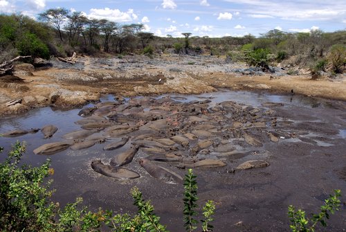
Along the Rufiji River, an array of
grazing antelopes, crocodiles and hippos are commonly seen as well as black and
white colobus monkeys in the riverine forests. During the dry season from June
to October, the concentration of animals along the river is astonishing. Linked
to the Rufii is Lake Tagalala where waterbuck, reedbuck and bushbuck gather at
the water's edge. Magnificent sickle-horned sable and curly-horned greater kudu
tend to keep to the longer grass and wooded shrubby areas.
In the dry season an ancient migration of elephants
takes place between the Selous and Mozambique's Niassa Game Reserves. This is
one of the largest natural trans-boundary eco-systems in Africa and at the last
consensus it was estimated that 64,400 elephants roam the two parks, with 84% on
the Tanzanian side. Fierce tiger fish and smooth slippery vandu catfish
are caught in the rivers. The latter is equipped with primitive lungs allowing
it to cross land for short distance in an attempt to find water water during the
dry season.
SEASONS Dry Season: The dry season sets in during June to November and is the
best time for game viewing along the rivers. Elephants come out of the bush at
that time and predators are more commonly seen. Rainy
Season: January to April is wonderful for birdlife ad lush scenery but
many roads become impassable after heavy rains. December to February is still
good for game viewing but can be rather hot and humid. The safari lodges are
usually closed from March to May.
SELOUS SPECIALITIES
• Rare and endangered Wild Dog •
Boat game viewing • Fishing • Thousands of migrating elephants •
Walking safaris • Huge wilderness
FACTS This massive stretch of land is the second
largest game reserve in Africa. At over 21,000 miles² (55,000 km²) it is almost
four times the size of the Serengeti. The only human habitations allowed are
limited tourist facilities. Road access is only possible during the dry
season and most visitors fly in from Dar es Salaam by charter
aircraft. Safari lodges are restricted to the top 20% of the reserve. This
is a malarial area.
The Serengeti is famed for its annual migration when more than 1,500,000 wildebeest follow some 200,000 zebra in a 2,000 km round pilgrimage in search of fresh grazing and water. It is "The greatest wildlife show on earth" !
"The greatest wildlife show on earth !"
Wildebeest feed only on new shoots and very short grass but do, of course, also eat longer grass once it has been 'trimmed' by zebra or buffalo. It is for this reason they follow the zebra Eland and Thomson's gazelle also migrate but do not follow the main migration but alternate between the plains and the woodlands. Grant's gazelle do not need to migrate as they are not dependant on water. They move only locally and, in many cases, in the opposite direction to the migratory species. Predator against prey dominates the migration as lion, leopard, cheetah, hyena and a host of smaller predators, watched by the everpresent vultures, feast on the carcasses of an abundance of plain grazers.
The best time to see the migration is usually between June and August when the wildebeest congregate and prepare to cross the Grumeti River. However the route and timing of the migration is unpredictable so visitors must plan carefully to be assured of seeing the spectacle. During the early wet season (December to April) the animals are found on the short grass plains around Lake Ndutu, the Moru Kopjes, the Gol Mountains and Seronera in the south of the park. February is the main month for wildebeest calving. During the late wet season (April to June) vast herds, in columns over 40 km long, head towards Kirawira, Mbalageti and Grumeti in the Western corridor. Then, in June, with the rains coming to an end they face the death-defying crossing of the crocodile-infested Grumeti River into the Ikorongo Controlled Area. Other smaller herds move directly north through the Seronera area while some travel up the eastern boundary of the park through the Loliondo and Lobo areas. During the early dry season (July to October) all migratory herd heads north. Many via the Mara River, another life threatening experience, before crossing the border into Kenya's the Masai Mara. Finally, in the late dry season (October to December) the herds start their trek back south to the Serengeti. Most herds arriving back at the short grass plains to give birth to their young. December being the peak month for zebra births. And then the cycle starts again. As it has for over a million years !
The fifteen parks managed by Tanzania National Parks offer a lot more than game drives to view the spectacular wildlife !
Bird Watching, Boat Trips, Canoeing Safaris, Chimpanzee Tracking, Fishing, Hiking, Hot Air Ballooning, Mountain Biking, Mountain Climbing, Swimming, Snorkelling and Walking Safaris are among just some of the activities available to visitors.
Lake Tanganyika lies along the border between Tanzania and Congo. The lake is 675km long, and has an average width of 50km. The lake has a depth of 1,435m and is therefore the second deepest lake in the world. The lake’s water is crystal clear and it has the reputation of being the cleanest lake in the world. The lake is known to be millions of year old and because of its age and isolation it is one of the most biologically rich lakes in the world and is home to over 500 species of fish (though it may well be over a 1,000) of which more than 90% are unique to Lake Tanganyika. To say the least, the beaches on the shores of Lake Tanganyika are all stunning, and snorkelling and diving is an attractive possibility in this age-old lake with it unique aquatic habitat. As Lake Tanganyika has a particular layer of soil on the bottom, which purifies the water naturally and makes the lake as clean as it is, there is no bilharzia in the lake like in other fresh water. Therefore the lake is safe to swim in, though around the beaches where the locals go to fish, bath, and wash clothes it might be more risky. One of the most beautiful beaches in the area is Amani Beach, which is perfect for a day of relaxing and getting wet.
Katonga
The small fishing village of Katonga lies some 5 km from Kigoma centre and is easily reachable by daladala which frequently takes off from the railway station. In this authentic fishing village you can watch traditional fishing and you can see how the dagaa fish are being dried in the sun on the hills, which gives the hills an amazing silver appearance. At night, fishermen go on the lake with little wooden boats to catch the small dagaa fish and to consequently light up the lake with hundreds of small lights.
MV Liemba
The MV Liemba is the oldest ship in the world that is still running and was originally named Graf Von Goetzen. It was built in Germany in 1913 and the ship arrived in Kigoma in pieces, shipped from Dar Es Salaam by railway just before the outbreak of the First World War. During the early months of the war it carried some 700 soldiers to Kasanga, though it was done away with by the Germans in the mouth of River Malagarasi, to be certain that it would not fall into the hands of enemies. In 1927 however it was salvaged by the British and Belgians, who ruled the area after WWI. It was then renamed MV Liemba, as, according to Dr. Livingstone, Liemba was the local name for Lake Tanganyika. An often repeated story says that the MV Liemba has been the inspiration for the novel The African Queen and that it has even been used in the film version, though whether that is true or not it is still a fascinating ship.
The ship is now being used as main ferry on Lake Tanganyika. It makes a weekly round trip from Kigoma to Mpulungu in Zambia and back to Kigoma. The ferry also goes to the Mahale Mountains and numerous lakeshore villages, though to get off in smaller villages one has to take a smaller boat to reach the coast.
German remainders
On a hill halfway to Katonga are the remainders of some First World War German fortifications. The place intended for the 105mm naval gun that was taken from the MV Liemba is the most interesting one of the remains. When the Germans left Kigoma, the gun was carried away to be never found again. There are several bunkers, old ammunition stores and interconnecting channels. It is said that one of these channels runs from the regional commissioner’s office to the train station, though nobody knows all the precise details of this.
Ujijij town
The old town of Ujiji lies at some 7 km from Kigoma to the south and was for centuries the main port where salt from Uvinza (see below) was shipped to Congo. Around 1800 Arab traders took over the town and made it the lakeshore terminal of the most important slave and ivory route to Bagamoyo. Though the town is most famous for the meeting between the explorers Stanley and Dr Livingstone in 1871, when Stanley spoke the words “Dr Livingstone, I presume?” At that place, now the Dr Livingstone Memorial is situated and the Livingstone Museum is next to it. At the museum on Wednesdays, Fridays, and Sundays from 17:00-18:00 the Washirika Dance Troupe practises traditional Ha dance and everyone is free to watch the practices. Another interesting spot in Ujiji is the harbour, which is very close to the Livingstone Museum and Memorial. There you can watch the practices of traditional fishing.
Gombe Stream National Park
Gombe Stream is Tanzania’s smallest National Park and is famous for its chimpanzees and the world-famous research done by primatologist Jane Goodall. This park is one of the few places in the world where chimpanzees are able to be approached very closely, which makes it a unique experience. Besides chimpanzees, the park is home to many other primates, such as baboons, red-tailed and blue monkeys, and red colobus monkeys, and other wildlife. Since the rest camps are within the park borders, monkeys just walk around the accommodation and in the morning when waking up you will be greeted by baboons trying your door to steal your food.
The park entrance is $100 per 24 hours spend in the park as from the moment you enter the forest. Besides a $10 guide fee will be asked for per party of up to 5 people and a stay at the rest camp per night costs $20 per person. A new guesthouse will be opened at the end of July 2008, which is more exclusive and therefore will likely be more expensive to stay in. Food and drinks are not available at the rest camp, though it will be available in the new guesthouse. Currently one needs to bring food and drinks for themselves for the whole stay, though there is a woman at the park who sells drinks for Tsh1,000 and a simple Tanzanian meal for Tsh5,000.
Transport needs to be arranged by oneself as well. You can try to get a free lift at the Jane Goodall Insitute (on the way to Katonga) which regularly has boats going to and from Gombe to bring and pick up staff. Though there is no fixed time or day and therefore one can also take a boat taxi at Kibirizi (along the way past Nzimano Hotel) which leave everyday (except Sunday) between 13:00 and 14:00 and charge Tsh3,500 per person. These boats take about 3 hours to reach Gombe and on the way back the boats are at Gombe around 8:00. This means that one will most likely have to stay in the park for two nights if you want to go chimp tracking for a whole day.
Note that there are strict rules to be followed when going into the forest. If you are sick, you are not allowed in the park, as a small harmless cold to us might kill a whole family of chimpanzees. Also children under 15 are not allowed in the park for the safety and health of the animals.
More information about Gombe Stream, as well as Mahale Mountains (see section below), can be found on www.tanzaniaparks.com.
Mahale Mountains National Park
The national park of Mahale Mountains lies some 100 km to the south of Kigoma. The park is some 30 times larger than Gombe and has a chimp population that is being estimated at about 800 animals. The Mahale Mountains National Park is considered as being a large-scale version of Gombe. The park is so large the chances of seeing chimpanzees is smaller than in Gombe, though one would be very unfortunate to not have seen at least one after two or three days in the park. Entrance fee to the park is $50 per 24 hours plus $20 per party for a guide and per party $20 fuel costs for the boat who brings you to the starting point of the hike. On top of that, one should take into consideration accommodation and food prices as well.
The park is reachable by ferry, though takes about 15 hours to reach the Mahale Mountains. One can also go by bus to Kalelani which is right outside the park entrance and where all park fees must be paid. Ten km from there is the tourist camp where accommodation is situated and which is the start of the chimp tracking. Mahale Mountains apply the same strict rules for chimp tracking as in Gombe Stream.
Katavi National Park
Katavi National Park is a beautiful park to observe wildlife in their natural habitat. Rarely visited by tourists, this park is the perfect destination for adventurous travellers. Many of the famous African animals can be found here, such as elephants, giraffes, lions, buffalos, hippos, and many more.
Katavi National Park is very well reachable from Kigoma. There are many daladalas going daily to Kasulu, and from Kasulu there is a direct bus to Mpanda, which leaves in the morning and arrives in Mpanda late in the afternoon. The bus goes on to Mpanda on Monday and Friday and back to Kasulu on Tuesday and Saturday. There are many guesthouses in Kasulu to stay at for one night as to take the bus in the early morning. There is also a train going from Kigoma to Mpanda, but you have to switch trains in Tabora.
There are daily daladalas going to Sitalike, a village at the entrance of the park. The fee for 24 hours in the park is $20 per person for non-residents and a guide fee is $10. One can hire a park vehicle to go into the park, but hiking is also allowed in some parts of the park. Another option is to try to arrange transport in Mpanda for the day, by hiring e.g. a 4x4 daladala to drive you around in the park. This may be cheaper, but requires Kiswahili knowledge.
Moyowosi Game Reserve
Moyowosi is a game reserve situated near Kibondo in the Kigoma Region. The game reserve has a surface of more than 10,000 km2 and therefore comprises a huge ecosystem. In the game reserve you can find many big African animals, such as the elephant, the giraffe, the buffalo, the lion, and many more. So to enjoy African wildlife you can find it all in Kigoma region!
River Malagarasi
The river of Malagarasi is the largest river in the area which originates near the border of Burundi. It is surrounded by beautiful indigenous forests and has numerous waterfalls spread over the whole river. At the mouth of the river hippos and crocodiles can be seen regularly.
Uvinza’s salt springs and Salt Factory
The name Uvinza means ‘place of salt’ and is situated along the central railway between Kigoma and Tabora. In the town of Uvinza a salt mine is situated which has been in operation for over 1,500 years. The salt used to be transported via Ujiji to what currently is the Democratic Republic of Congo and is the only salt reserve in the region of Kigoma. Nowadays Uvinza has a salt factory which supplies the whole region with salt.
The specimen of Giraffatitanbrancain the central exhibit hall is the largest mounted dinosaur
skeleton in the world.
It is composed of fossilized bones
recovered by the German paleontologistWerner
Janensch from the fossil-rich Tendaguru beds of Tanzania between 1909 and 1913. The remains are primarily from one
gigantic animal, except for a few tail bones (caudal vertebrae) which belong to another animal of the same size and
species.
The mount is 12.72 m (41 ft 5 in)
tall, and 22.25 m (73 ft) long (as of 2005). When living, the long-tailed,
long-necked herbivore
probably weighed 50 t (55 tons).
While the Diplodocuscarnegiei mounted next to it (a copy of an
original from the Carnegie Museum of
Natural History in Pittsburgh, United States)
actually exceeds it in length (27 m, or 90 ft), the Berlin specimen is taller,
and far more massive.
Tanzania is a country which encompasses an extraordinary history and an abundance of natural wonders; therefore it is no surprise Tanzania has eight World Heritage Sites. These chosen sites are a fundamental reminder why interaction between people and nature must achieve a balance of preservation and conservation between the two.
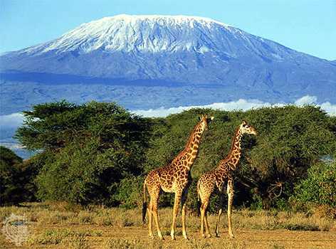
Kilimanjaro National Park.
The Kilimanjaro National Park is located near Moshi, Tanzania.It is centred on the iconic and dramatic snow-cloud slopes of Mount Kilimanjaro, which covers an area of 753km (291 square miles). In 1973, the mount above the tree line was classified as a National Park and was opened to public access in 1977, but it wasn't until 1987 UNESCO listed the park as a World Heritage Site.
Kondoa Rock Art Sites.
The Kondoa rock art site is a series of caves carved into the side of a hill looking out over the steppe. The cave site is nine kilometers off the main highway from Kondoa to Arusha, about 20km north of Kondoa.The site has a spectacular collection of images from over 150 shelters depicting elongated people, animals, and hunting scenes.Today many of the shelters are still considered to have ritual associations with the people who live nearby, reflecting their beliefs, rituals and cosmological traditions.
The Ngorongoro Conservation Area.
The Ngorongoro Conservation Area (NCA) boasts the finest blend of landscapes, wildlife, people and archaeological sites in Africa and is situated 180km west of Arusha. The rich pasture and permanent water of the Crater floor supports a large resident population of wildlife of up to 25,000-predominantly grazing animals. The conservation area is administered by the Ngorongoro Conservation Area Authority, and its boundaries follow the boundary of the Ngorongoro Division of Ngorongoro District. It covers an area of 8,288km (3,200 square miles).
Selous Game Reserve.
The Selous Game Reserve covers a total area of 54,600km (21,081 square miles) and is one of the largest fauna reserves of the world, located in the south of Tanzania. It was designated a UNESCO World Heritage Site in 1982 due to the diversity of its wildlife and undisturbed nature.The reserve is home to typical savannah animals such as elephants, hippopotami, the rare African Wild Dog and crocodiles, which are all found in large numbers compared to any other African park.
Serengeti National Park.
The Serengeti National Park is Tanzania's oldest park, and one of the world's last great wildlife refuges, hence its World Heritage Site status.It is most famous for its annual migration of over one million white bearded (or brindled)wildebeest and 200,000 zebra. The park covers 14,763km (5,700 square miles) of grassland plains and savannah as well as riverine forest and woodlands.The park lies in the north of the country, bordered to the north by the national Tanzania and Kenyan border, where it is contiguous with the Masai Mara National Reserve.
Stone Town, Zanzibar.
Stone Town or Mji Mkongwe in Swahili meaning "ancient town" is the oldest part of Zanzibar city. The oldest town is built on a triangular peninsula of land on the western coast of the island and was awarded World Heritage Site status in 2000. Justification for the inscription, includes its rich cultural fusion and harmonization. Its great symbolic importance in the suppression of slavery, and the intense seaborne trading activity between Asia and Africa, which is illustrated today in the exceptional architecture and urban structure of Stone Town.
Ruins of Kilwa Kisiwani and Ruins of Songo Mnara.
The remains of two great East African ports admired by early European explorers are situated on two small islands near the coast. From the 13th to the 16th century, the merchants of Kilwa dealt in gold, silver, pearls, perfumes, Arabian crockery, persian earthenware and chinese porcelain, much of the trade in the Indian Ocean thus passed through their hands. Serious archaeological investigation began in the 1950s. In 1981 it was declared a World Heritage Site, and noted visitor sites are the Great Mosque, the Mkutini Palace and some remarkable ruins. However, the ruins are also on the List of World Heritage in Danger. The list constitutes a call to improve their safeguiding and is designed to rally national and international efforts for their preservation.
The ruins of Maruhubi Palace can be found four kilometres north of Zanzibar Town, just a few steps from the beach. The palace is named after the former landowner, an Arab of the Al-Marhuby tribe.
2 of 6
Preloaded: 0000601.jpg
Between 1880-1882 the palace was built by Sultan Barghash, the third Arab sultan of Zanzibar, who used the building to accommodate his wife and about 100 concubines. The sultan himself lived in a separate palace in Zanzibar Town. In 1899 the Maruhubi Palace was destroyed by a fire, leaving only a few remains, including some massive stone columns which supported a large wooden balcony which surrounded the upper floor. In the old Persian-style bathhouse, the separate bathrooms for the women and the sultan's own large bathroom can still be seen. On the same grounds are the original water reservoirs now overgrown with water lilies and large mango trees once imported from India.
Nowadays, the beach behind the palace is used by fishermen as a harbour and a place to maintain their traditional dhows. A small admission fee to visit the ruins may be charged by a guard.
Tanzania has a long history of human habitation stretching back to our most distant ancestors. The so- called 'Bantu Migrations', occurring between 3,000 and 5,000 years ago, brought agricultural and pastoral knowledge to the area as competing groups spread over the country in search of fertile soil and plentiful grazing for their herds.
European missionaries and explorers mapped the interior of the country by following well-worn caravan routes, including Burton and Speke who in 1857 journeyed to find the source of the Nile. Traditional ways of life remained largely intact until the arrival of German colonisers in the late 19th century.
On the Swahili Coast, Indian Ocean trade began as early as 400BCE between Greece and Azania, as the area was commonly known. Around the 4th century AD, coastal towns and trading settlements attracted Bantu-speaking peoples from the African hinterland. They settled around mercantile areas and often facilitated trading with the Arabs and Persians, who bartered for slaves, gold, ivory and spices, sailing north with the monsoon wind.
Between the 13th and 15th centuries, the settlements of Kilwa Kisiwani and the Zanzibar Archipelago reached their peak, with a highly cosmopolitan population of Indian, Arab and African merchants trading in luxury goods that reached as far as China. The completion of Portuguese domination in 1525 meant that trade, for a short time, was lessened, but rival Oman Arab influences soon took control of the caravan routes and regained complete control of the islands, even going so far as to make Zanzibar the capital of Oman in the 1840s.
In the late 19th century, British influence in the Zanzibar Archipelago, in contrast to German influence on the Tanzanian mainland, slowly suppressed the slave trade and brought the area under influence of the Empire. Local rebellions in German East Africa, most notably the Maji Maji rebellion from 1905 to 1907, slowly weakened the coloniser's grip on the nation and at the end of the First World War German ceded Tanganyika to English administration. Under the leadership of Julius Nyerere of TANU, popularly referred to as Mwalimu, or 'teacher', Tanganyika achieved full independence in 1962. Meanwhile, a violent revolution in Zanzibar ousted the Omani Sultancy and established a one-party state under the Afro-Shirazi Party in 1963. A year later, the United Republic of Tanzania was formed, unifying the Tanganyika mainland with the semi-autonomous island of the Zanzibar Archipelago, and merging TANU and the ASP to form CCM, Chama cha Mapinduzi, the party of the Revolution which rules Tanzania to the present day.
ENGARUKA.
Mysterious ruins of complex irrigation systems span the area around Engaruka, the remnants of a highly developed but unknown society that inhabited the area at least 500 years ago-and then vanished without a trace.
Engaruka is situated 63 kilometre north of Mto wa Mbu, on the road to
Oldoinyo Lengai and Lake Natron.The village of Engaruka lies at the foot of the
rift valley escarpment. Fast flowing streams from the escarpment are utilised to
irrigating small plots and give the village a pleasant green look,in contrast to
the surrounding plains where Maasai cattle graze side by side with herds of
zebras. Birds of prey circle above the area looking for a kill, while remarkable
looking secretary birds, beloved as snake killers strut across the plains. Dust
cyclones are often seen on the horizon, they are feared as " devils fingers",
bringing bad luck when they touch people.
Engaruka is one of Tanzania's most important historic sites. Some 500 years
ago, a farming community of several thousand developed an ingenious irrigation
and cultivation system. The water that flowed from the rift escarpment was
channelled into stone-built canals and led to stone-bench terraces. Measures
were taken to prevent soil erosion and the fertility of the plots was increased
by using the manure of stall fed cattle. For unknown reasons, the farmers left
Engaruka around 1700. Now, three centuries later, the ruins still give a good
impression of the highly specialised , integrated agricultural economy, very
remarkable for that period of African history
Engaruka historical village.
Engaruka is an abandoned system of ruins in the Great Rift Valley of northern Tanzania, famed for its irrigation and cultivation system. It is considered one of the most important Tanzanian archaeological sites.
Sometime in the 15th century, an iron age farming community with a large continuous village area on the footslopes of the Rift Valley escarpment, housing several thousand people developed an intricate irrigation and cultivation system, involving a stone-block canal channelling water from the “Crater Highlands” rift escarpment to stonelined cultivation terraces.
Measures were taken to prevent soil erosion and the fertility of the plots was increased by using the manure of stall fed cattle. For an unknown reason Engaruka was abandoned at latest in mid-19th century.
The site still poses many questions, including the identity of the founders, how they developed such an ingenious farming system, and why they left. The site has been linked to the Sonjo, a people living some 60 miles to the northwest known for their use of irrigation systems in agriculture and similar terraced village. New studies have revealed lot of unknown perspectives of the past of Engaruka, for example the Middle Stone Age and Neolithic Stone Age occupation history of the area.
The first explorer to record the existence of these ruins was Dr. Gustav Fisher, who passed them on July 5, 1883, and compared them to the tumbled-down walls of ancient castles. Drs Scoeller and Kaiser mentioned the ruins of “Ngaruku” including great stone circles and dams in 1896-97. The first detailed and archaeological investigation was by Hans Reck, in 1913.
Engaruka ruins.
KILWA KISIWANI.
The Island of Kilwa Kisiwani and the nearby ruins of Songo Mnara are among the most important remnants of Swahili civilisation on the East African coast. The area became the centre point of Swahili civilisation in the13th century, when it controlled the gold trade with Sofala, a distant settlement in Mozambique. After a brief decline under the rule of the Portuguese, Kilwa once again became a centre of Swahili trade in the 18th century, when slaves were shipped from its port to the islands of Comoros, Mauritius and Reunion.
The dinosaur remains we discovered in 1912 at Tendeguru Village.
MIKINDANI.
Another central port in the Swahili Coast's network of Indian Ocean trade, in the 15th century Mikindani's reach extended as far as the African hinterlands of the Congo and Zambia. The area became a centre of German colonial administration in the 1880's and a chief exporter of sisal, coconuts and slaves.
Mikindani (or Mikandani) means 'young palm trees' in KiSwahili. Mikindani is an old historical Swahili town, with over 50 ruined building dating back to pre-colonial times. It lines the shores of Mikindani bay, a safe and secluded harbour to the north of Mtwara - the regional capital.
The original Inhabitants of Mikindani were the Makonde Tribe who were joined in the 9th Century AD by Arab traders. A further influx of Arabs occurred in the 17th century under the Sultan Seyyid Said, the graves and mosques from this period can be seen.
In the 19th century under German colonial rule the fort (boma) a prison and a dock were constructed in the village. During World War I the prison was largely destroyed, what remained was turned into a customs house. In 1947 the British moved their base for the area to Mtwara where there is a superior harbour.
The town is set on the rolling hills of the southern coast of Mikindani Bay. this bay is a small heart shaped bay. The southern arm of the bay contains a small number of houses (and a holiday complex) called Litingi. On the far side of the bay mouth there is a small fishing village called Pemba.
The Town is right on the main Mtwara-Lindi road, about 10km from Mtwara. The town can be reached easily from Mtwara via regular bus services.
After Mtwara was founded and the local government moved there, Mikindani became a backwater. It has a large market and several restaurants. The town has increased in prosperity during the past decade, starting with the renovation of the boma as a hotel in the late 1990s. Since then other hotels, bars and a yacht club have been founded. Despite this, the majority of the population exists from subsistence farming.
The town is mainly Muslim though there is a significant Christian population.
It has access to excellent long sandy and unpopulated beaches, snorkeling, world class diving, in the Mnazi bay marine park with ECO2 diving center, Mkonde and Rubondo plateaus and for a longer day out, the Newala Game reserve.
There are a couple of places to stay - the Old Boma being the highest standard - an old German building now renovated into a 5 star hotel, and the more economical 10 Degrees South - part of the ECO2 diving center.
The town is home to Livingstone House, the place from which Dr. Livingstone set out on his last expedition.
The famous Dr Livingstone of "Dr Livingstone I presume" fame had a house here, which is still standing and in the process of renovation. The many other old ruined buildings are in a worse state of repair, however there is a project underway to restore them. A town walk is interesting as there are virtually no tourists at all.
NGORONGORO CONSERVATION AREA.
Humans and their distant ancestors have been part of Ngorongoro's landscape for millions of years. The earliest signs of mankind in the Conservation Area are at Laetoli, where hominid footprints are preserved in volcanic rock 3.6 million years old. The story continues at Olduvai Gorge, a river canyon cut 100 m deep through the volcanic soil of the Serengeti Plains. Buried in the layers are the remains of animals and hominids that lived and died around a shallow lake amid grassy plains and woodlands. These remains date from two million years ago. Visitors can learn more details of this fascinating story by visiting the site, where guides give a fascinating on-site interpretation of the gorge.
A view at Olduva Gorge on the way to Serengeti N.P.
ZANZIBAR.
The most obvious historical site in Zanzibar is Stone Town, a World Heritage Site and the oldest continuously inhabited city in East Africa, but Zanzibar has much more to offer visitors. From the ruins of numerous palaces stemming from the Omani sultancy, ancient, mosques (notably the mosque at Kizmkazi which contains the oldest known Swahili text), Persian bathhouses and colonial buildings ( in the Indian Colonial style), Zanzibar is an absolute treasure trove for the historically inclined.


 The dinosaur remains we discovered in 1912 at Tendeguru Village.


